Generally a quiet month that finished close to average
Overall a quiet month, but with a few distinct periods of mild and changeable conditions and also a spell that was something more akin to winter.
January got off to a mild and unsettled start before becoming more settled and cooler, but then the second half of the month saw a return to changeable conditions. This included a wintry period 16th-21st but then became quite mild, especially in the final week of the month.
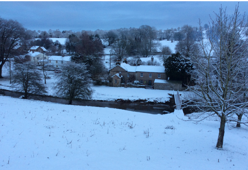
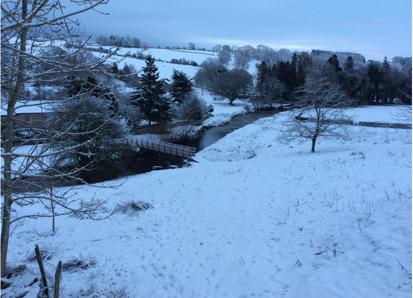
Snow lay on the ground for five days from the 17th, but without ever getting too cold and here in Cumbria we generally avoided the worst of 'Storm Eleanor' on the 2nd/3rd, but the 23rd/24th was wet and stormy with local roads becoming almost impassable due to flooding.
During the month, there was: one day of fog (11th), snow fell on 6 days and was laying on the ground (to a depth of at least 1 cm) on 5 days (17th to 21st).
MSLP of 1004.4 Mb was -7.7 Mb below the local average for January with pressure at its lowest 1st-5th with the month starting wet and again 14-20th during the wintry phase of the month.
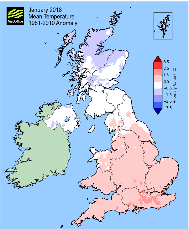
Overall a mean minimum of 1.47°c and a mean maximum of 6.11°c saw the temperature 0.4°c above the 1981-2010 average. It was the warmest since 2016 and of the ten now recorded, 6 have been colder and 3 warmer. The highest maximum temperature recorded was 12.4°c (28th), the lowest minimum -3.8°c (7th).
Rainfall of 133.7 mm (Crosby Ravensworth School 153.4 mm - Castlehowe Scar 177.5 mm - Reagill ??? mm) was 88.4% of average for 2007-17 and made it the wettest January since 2016. Of the eleven now recorded, 4 have been drier and 6 have been wetter.
Locally, rainfall percentages were typically above average, but not exclusively. Once again the Lake District was well above average, but this month the greatest positive departure from normal was to be found at Kirkby Thore, yet just up the road at Haresceugh Castle was one of the few sites that saw the average dip below normal!
At the Met' Office site at Newton Rigg, 114.2 mm (112.5%) made it the wettest January since 2016 and in a series back to 1900, January has been drier in 78 years and wetter in 40 years. A mean temperature of 3.95°c is the warmest since 2016 and in a series back to 1952, 45 have been colder, 19 have been warmer, with 2 having the same mean temperature.
Figures from the Environment Agency’s rainfall sites were, (figure in brackets being the monthly average for 1961-90) ‘Data kindly provided by the Hydrometry and Telemetry team of the Environment Agency (Penrith)’:
Kirkby Thore 92.8 mm (70.1 mm)
Haresceugh Castle (Kirkoswald) 85.85 mm (91.7 mm)
Brothers Water 335.44 mm (277 mm) and
Orton (Shallowford) 114.2 mm (186.8 mm [average for 1967-2017])
447.0 mm at Seathwaite Farm (Borrowdale - 372 mm [average for 1981-2010])
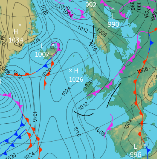
1st - 5th The year started on an unsettled note with a series of depressions visiting the UK that brought spells of rain and some strong winds. However, we avoided the worst of the year's first named storm 'Eleanor'.
New Year's Day started damp, but brightened for a while before rain arrived in the afternoon. The 2nd saw more organised rain through the day and after a brief pause, Storm Eleanor started to make its presence known.
Eleanor brought gusts of wind to 52 mph and a spell of heavy rain (23.1 mm) overnight into the 3rd, but moved quickly out into the North Sea. It remained unsettled with a further 10.7 mm of rain on the 4th on what was a grey and miserable day, before a quiet and cloudy day on the 5th as the pressure gradient slackened and we stayed clear of any fronts.
During the period temperatures were above normal, especially at night.
6th - 14th It then became more settled and cooler as high pressure (HP) built from the NW, becoming established over the UK and drawing down Arctic air on a NE'ly flow. From the 8th the HP pulled away to east Europe and whilst only weakly, the HP still ridged sufficiently over the UK to maintain the quiet spell of weather.
With clear and sunny skies, the temperature held up by day on the 7th, but all of the 7-9th saw night-time frosts, down to -3.8°c (25.2°f) on the 7th, a month's low.
Mist became frequent during the 9-11th, especially the 11th which was foggy during the morning as now the UK sat under a slack pressure gradient.
At the end of the period the HP was just managing to hold back fronts from off the Atlantic, but now the flow was from the S-SW and subsequently it became milder and whilst we lost the mist, it remained cloudy.
15th Became a transitional day as the fronts to the west of the UK which had been held at bay now moved east across the UK. Once those fronts had exited east it heralded the start of a wintry period.
 1200 Hrs 15th - The fronts moving across the UK which would herald several days of wintry conditions
16th - 21st Whilst not particularly cold, we then enjoyed a spell of wintry weather with snow laying on the ground for five successive days.
Once those fronts from the 15th had cleared away a brisk and cooler W'ly flow was introduced, which at first brought snow showers. Those showers arrived overnight into the 16th and gave a light cover come the morning and those showers continued through the day. However, with a slightly longer period of snow in the evening and then further showers overnight, the 17th started with a cover of 2 cms.
An area of LP had been developing in the Atlantic and would move ENE across the UK during the 18th, but tracked just to the south of Cumbria. To the north of this system we got snow (heavy for a while in the early hours of the 18th), to the south of the system it was rain and hence the day started with a cover of 5 cms (2 inch). The day saw more snow showers in the morning, but turned more to rain in the afternoon, however, we still had a 3.5 cm cover on the 19th.
The brisk W'ly flow was maintained behind this LP and we saw further wintry showers, but with some brighter moments. Avoiding the numerous troughs and fronts that were nearby, both the 19-20th saw clearer skies with the consequent dip in temperature, but due to the wind, not excessively so. The 21st started with the coldest temperature in the period, -3.4°c and despite slightly warmer temperatures during the day on the 20th, we still hung onto a slight cover of snow, but the 21st would be the last day.
There was to be a late final flourish of snow during the 21st as LP sat in the Atlantic pushed a frontal system north across the UK. For a period during the morning and early afternoon snow fell and was moderately heavy for a time. However, it was warming up all the time and eventually turned to rain - but it had provided the opportunity for one late dash to the toboggan slopes!
22nd - 28th Unsettled and becoming very mild as a series of depressions swept across the UK.
Whilst the passage of the frontal system had finally brought the milder temperatures late on the 21st, this more unsettled period started with a quiet day as a weak ridge of HP built from the Azores, but the temperature was up to 7.8°c.
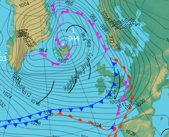
This was only ahead of a deep and vigorous LP system that would bring the worst weather of the month over the next two days. A series of fronts moved through on the 23rd, bringing a mild day at 9.6°c but with it rain that lasted through to tea-time. Whilst the fronts that brought this rain were associated to a semi-static area of LP in the Atlantic, now a new area of LP would arrive from the SW late on the 23rd and overnight into the 24th. This gave a spell of heavy rain in the early hours of the 24th (giving a final total of 27.2 mm for the 23rd) and which was accompanied by strong and gusty winds, notching up 63 mph, but were not quite strong enough to record a 'gale'.
The 24th started with our local roads under water for a time, creating detours for those not in a 4x4, but the rain finally eased off to a shower and blustery day as the LP system cleared NE.
The remnants of the LP out in the Atlantic finally moved east during the 25th, bringing some showers and light rain with the 'Azores High' ridging in again on the 26th to give a quieter day.
Now followed the mildest part of the month - a new area of LP approached the UK over the top of the HP and on a mild and brisk SW'ly flow the temperature rose sharply. Both the 27-28th saw some drizzle in the morning, but the 11.8°c of the 27th was more than matched by the 12.4°c (54.3°f) on the 28th.
29th - 31st The month the finished that little bit cooler as a cold front overnight into the 29th introduced less cold air.
It wasn't actually that cold, but it was certainly much fresher in a brisk W'ly flow and after the mildness of the previous days, the temperature fell away to 6.9°c on the 29th and was back below average come the 31st.
The days also enjoyed some sunny spells with just the odd shower and some rain overnight into the 31st as LP to the north of Scotland pushed fronts down over the UK and which would see the W'ly flow back NW'ly during the day.
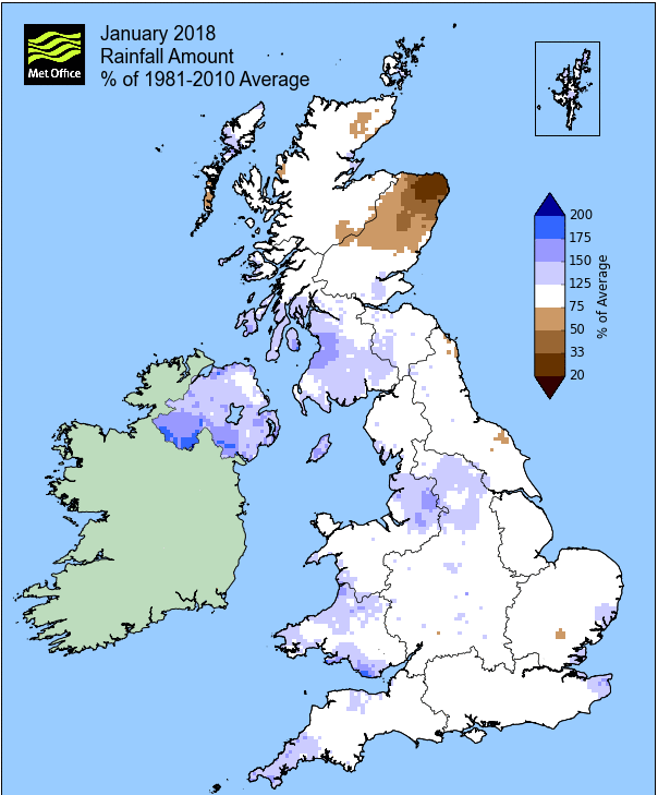
Rainfall totalled 133.7 mm for the month, with rain recorded on 23 days of which 20 were 'Wet days' (1.0mm +).
The Mean Temperature for the month was 3.79°c -- The Mean Max' was 6.11°c -- The Mean Min' 1.47°c.
We had 9 Air Frosts in the month (year 9) -- Grass frosts totalled 18 (year 18).
The 1 foot soil temp ranged from a low of 3.0°c on the 9-10th and 22nd to a high of 6.0°c on the 29th -- with a monthly mean of 4.3°c
The 1 meter soil temp ranged from a low of 5.7°c on the 23rd to a high of 6.6°c on the 4-7th -- with a monthly mean of 6.2°c
COMPARISONS:-
* January 2018 rainfall was 88.4% of the January average for 2008 - 2017
* January 2018 was 0.62°c warmer than the January average for 2009 - 2017 and 0.4°c warmer than the local long term average 1981-2010
JANUARY 2010
FEBRUARY 2010
MARCH 2010
APRIL 2010
MAY 2010
JUNE 2010
JULY 2010
AUGUST 2010
SEPTEMBER 2010
OCTOBER 2010
NOVEMBER 2010
DECEMBER 2010
JANUARY 2011
FEBRUARY 2011
MARCH 2011
APRIL 2011
MAY 2011
JUNE 2011
JULY 2011
AUGUST 2011
SEPTEMBER 2011
OCTOBER 2011
NOVEMBER 2011
DECEMBER 2011
JANUARY 2012
FEBRUARY 2012
MARCH 2012
APRIL 2012
MAY 2012
JUNE 2012
JULY 2012
AUGUST 2012
SEPTEMBER 2012
OCTOBER 2012
NOVEMBER 2012
DECEMBER 2012
SUMMER 2012
REVIEW OF 2012
JANUARY 2013
FEBRUARY 2013
MARCH 2013
APRIL 2013
MAY 2013
JUNE 2013
JULY 2013
AUGUST 2013
SEPTEMBER 2013
OCTOBER 2013
NOVEMBER 2013
DECEMBER 2013
REVIEW OF 2013
JANUARY 2014
FEBRUARY 2014
MARCH 2014
APRIL 2014
MAY 2014
JUNE 2014
JULY 2014
AUGUST 2014
SEPTEMBER 2014
OCTOBER 2014
NOVEMBER 2014
DECEMBER 2014
WINTER 2014
REVIEW OF 2014
JANUARY 2015
FEBRUARY 2015
MARCH 2015
APRIL 2015
MAY 2015
JUNE 2015
JULY 2015
AUGUST 2015
SEPTEMBER 2015
OCTOBER 2015
NOVEMBER 2015
DECEMBER 2015
REVIEW OF 2015
JANUARY 2016
FEBRUARY 2016
MARCH 2016
APRIL 2016
MAY 2016
JUNE 2016
JULY 2016
AUGUST 2016
SEPTEMBER 2016
OCTOBER 2016
NOVEMBER 2016
DECEMBER 2016
REVIEW OF 2016
JANUARY 2017
FEBRUARY 2017
MARCH 2017
APRIL 2017
MAY 2017
JUNE 2017
JULY 2017
AUGUST 2017
SEPTEMBER 2017
OCTOBER 2017
NOVEMBER 2017
DECEMBER 2017
REVIEW OF 2017
OTHER ARTICLES
The Oldest Inhabitant
An Inch Of Scotch Mist
© Darren Rogers 2010-18
Want to comment on this site? email